12. GIS — basemap and geographic data
The GIS tab places a drawing on real geographic coordinates (latitude / longitude), shows a basemap (streets, satellite…) under the drawing, and imports / exports GeoJSON and KML data.
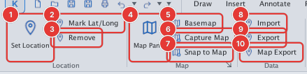
| Page | What it covers |
|---|---|
| Locating the drawing | GEOREF / GEOGRAPHICLOCATION, GEOMARKLATLONG, GEOREMOVE, coordinate system |
| Basemap | GEOMAP, opacity, the GIS panel, offline mode |
| Capturing the map as an image | GEOMAPIMAGE (GEOSNAP) — insert the map as an image for plotting |
| GIS import / export | IMPORTGIS, EXPORTGIS, MAPEXPORT: GeoJSON, KML, GPX |
The basemap comes from OpenStreetMap (and a few other sources) over the network; tiles you have viewed are kept in ~/.kufcad/tilecache so you can view them again without a network.
The pictures in this chapter were taken from the cached tiles of the Hanoi area.